
The Mount Agung hike takes you to the top of the biggest and baddest volcano peak on the island of Bali, Indonesia, and the sunrise views are out of this world.
This epic and brutal trek takes you up the steep slopes of an active volcano until you’re staring into the massive crater itself.
I climbed Agung recently, and it was one of the most difficult and thrilling hikes I’ve ever experienced. There are two main routes for trekking the volcano, and they each have their own challenges.
UPDATE: Since January 3, 2025, Mount Agung is temporarily closed for hiking because of storms and heavy rain making the trail unsafe. I’ll update this guide when there’s new information.
The Mount Agung volcano is located in Karangasem regency, in the northeast corner of Bali island.
It’s about 1.5 hours’ drive from Ubud, or 2 hours’ drive from Kuta, Canggu, and Sanur.

Mount Agung volcano as seen from Sidemen village
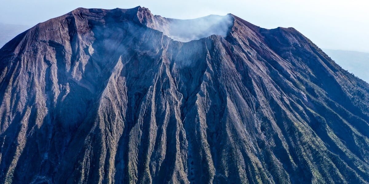
Mount Agung (also known as Gunung Agung in Indonesian) is the highest point in Bali, and at 3,142 meters it’s one of the top 100 prominent peaks on Earth. My wife informs me that the name means ‘Great Mountain’.
Gunung Agung was long considered the ‘navel of the world’ by Balinese, and it’s still sacred in their beliefs. If you do this hike with a local guide, he’ll make a few stops along the way to burn Hindu incense and pray.
Balinese respect mountains as the dwelling place of the gods, and in old times you couldn’t climb Agung without a Hindu priest present.

Mount Agung sunset as seen from Amed village
Mount Agung is an active volcano that’s had some major eruptions throughout history. In 1963, a catastrophic eruption wiped out the nearby villages and killed 2,000 people.
The last Mount Agung eruption was the one in 2017-2019, when it exploded with a giant 4 kilometer tall ash cloud that caused mayhem in Bali. More than 100,000 locals in Karangasem were evacuated, and hundreds of tourist flights were canceled or diverted.
Nowadays, any signs of impending volcanic activity at Agung are constantly monitored by the Indonesian government, and if there are tremors sometimes the mountain is closed to hikers.

Mount Agung eruption in 2017 (© Shutterstock)

Mount Agung eruption in 2017 (© Shutterstock)
Obviously there is no guarantee of safety if you climb Agung. This is an active volcano, so there will always be some measure of risk involved.
However, it seems the catastrophic eruptions are usually spaced apart by several decades (after a long buildup of pressure), and most years don’t see any significant volcanic activity at all.
Personally I found the risk level acceptable, and I would love to climb Agung again sometime. Know your limits, though! This is a serious hike and you need good mobility.
There have been at least half a dozen falling deaths on the Mount Agung hike over the years, including two in 2024 and one so far in 2025.
However, deaths on the mountain have generally been a result of unfit / older hikers, bad weather, and/or hiking without a guide.
As of 2025, Mount Agung is currently at Level 1 alert status (‘normal’) according to the Indonesian government’s volcanological survey.
This is the lowest risk level, and it means there are no safety barriers to climb the mountain now.
However, it’s worth noting that Mount Agung is closed to hikers during certain months of the year for Hindu ceremonies, such as Ida Bhatara Turun Kabeh (IBTK) and Tawur Labuh Gentuh.
In 2024, the ceremony dates were March 17 to April 14, and October 1 to November 30. The mountain was completely closed for hiking during these dates.
UPDATE: Since January 3, 2025, Mount Agung is temporarily closed for hiking because of storms and heavy rain making the trail unsafe. I’ll update this guide when there’s new information.

Looking into the crater of the Mount Agung volcano. What a hike.
Here is a Mount Agung trekking tour package that you can book online.
They offer the sunrise trek starting from either Pasar Agung Temple or Besakih Temple, although it’s more cost effective if you go with a friend (they charge a 2 pax minimum).
We’ve used Klook for lots of tours and activities around the world, and they’re great. Highly recommended!
Sunrise Trekking
Most people do Mount Agung as an overnight hike, in order to arrive at the top for sunrise. One of the main benefits of this is that the early morning tends to be clear more often than not, whereas the volcano is usually totally covered with clouds in the daytime.
Mount Agung sunrise tours start with a very early pickup (maybe 11 PM-ish) so your guide can drive you to the trailhead for a hike to the top of the volcano in time for sunrise.
This means you’ll be operating on very light sleep (if any at all), compounding the difficulty of the whole trek. Ever tried staying up all night while hiking for 8 to 12 hours on an extremely steep, rocky volcano in the dark? Chances are, probably not.
The Mount Batur sunrise hike is a good warmup for this one because the mechanics and terrain are similar, although Batur is much shorter and easier than Agung.
The Mount Agung trek can be broken down into 3 phases:
My wife, bless her heart, gave up shortly after we exited the treeline. She was too exhausted to keep going, the path was getting more sketchy, and the wind that day (late August) was terrible. We agreed to keep the guide with her for safety, and I pressed on to the summit alone in the dark.
The fact that my headlight was weak and I was running late for sunrise added some more urgency. I’ll never forget that moment: I was clinging to the side of a steep volcano, half asleep and beat to pieces, when the sky turned orange and I realized I was high above the clouds.
It was a really special moment.

First peep of sunrise on the Mount Agung trek

High above the clouds. This was one of the less steep sections near the end.
Ahead, you have the huge smoking 900-meter-wide crater of Agung, and you get to look straight down into it from the crater rim.
Watch your step, because there’s not much walking space at the top and people have fallen into the crater. You don’t want to be a sacrifice to the gods.
The views at the top are otherworldly. To the east and west, you can see the far off peaks of Mount Rinjani and Mount Abang, along with the giant Batur caldera in Kintamani. To the south, you can see all the way to Kuta.
The beauty of the hike is only outweighed by the difficulty and sense of achievement when you reach the summit.

On this day, the crater rim was packed with locals doing the Mount Agung trek.

Drone picture of the Agung crater.
The Mount Agung hike is very, very hard. It’s brutal. Mount Batur is a joke by comparison. The Agung hike is several times harder than Batur.
The last part of the hike is very steep, and in some places you’ll be climbing almost vertical in the dark. There were times when I seriously considered turning back, which is an unusual feeling for me.
For reference, I’ve hiked almost a dozen ’14ers’ in Colorado, Hawaii’s illegal Stairway To Heaven, the Kalalau Trail, Half Dome, and other famously difficult hikes, but Agung is still one of the hardest things I’ve ever done.
After the trek, we ate two meals each, collapsed at our hotel in Amed, and slept for 16 hours straight. We could barely walk for days.

The wind kicked up so much dust and smoke it almost looked like the volcano was erupting!

High above the clouds on Gunung Agung
There are two main routes for hiking Agung. One starts from the famous Besakih Temple, while the other starts from a smaller temple called Pura Pasar Agung:
Both routes are very difficult. The Pasar Agung route gives better views of the inside of the volcano crater, while the Besakih route ends on a tall ridge with great views of the whole landscape.
From the Pasar Agung trail it used to be possible to also reach the final summit using a side path that joins the Besakih trail partway up, but apparently this path was ruined in the 2017 eruption.

Pura Besakih temple pagodas

Pura Pasar Agung main temple gate